Cambridge, MA Weather
If you just finished a run, get the hourly history including humidity and wind speed (scroll down in the page to see the tabular data).
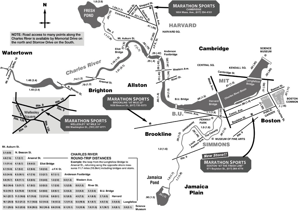
Calculate times and distances for running between the bridges on the Charles River in Cambridge/Boston, MA, or calculate your pace, given a set of bridges and times. (Or scroll directly down to a map.) Calculator created by Hector Briceño, and is Copyright 2001 (please do not copy it).
If you just finished a run, get the hourly history including humidity and wind speed (scroll down in the page to see the tabular data).
Instructions: Set the distance (either by writing it in, or selecting two bridges). This is the LOOP distance to run up one side, across and down the other side.
| Bridge | Science Museum | Longfellow Br | Harvard Br | BU Bridge | River St | Western Ave | Weeks Footbridge | Larz Anderson | Eliot Br | Arsenal St | N Beacon St | Watertown Sq. |
|---|---|---|---|---|---|---|---|---|---|---|---|---|
| Watertown Sq | 17.08 | 16.13 | 14.07 | 12.32 | 10.15 | 9.75 | 9.18 | 8.63 | 7.14 | 4.62 | 3.04 | |
| N. Beacon St | 14.16 | 13.21 | 11.15 | 9.39 | 7.22 | 6.83 | 6.26 | 5.71 | 4.22 | 1.7 | 3.04 | |
| Arsenal St | 12.66 | 11.71 | 9.65 | 7.89 | 5.72 | 5.33 | 4.76 | 4.21 | 2.72 | 1.7 | 4.62 | |
| Eliot Br | 10.18 | 9.23 | 7.17 | 5.41 | 3.24 | 2.85 | 2.28 | 1.73 | 2.72 | 4.22 | 7.14 | |
| Larz Anders | 8.63 | 7.68 | 5.62 | 3.86 | 1.69 | 1.3 | 0.73 | 1.73 | 4.21 | 5.71 | 8.63 | |
| Foot bridge | 8.12 | 7.17 | 5.11 | 3.35 | 1.18 | 0.79 | 0.73 | 2.28 | 4.76 | 6.26 | 9.18 | |
| Western Ave | 7.47 | 6.52 | 4.46 | 2.7 | 0.53 | 0.79 | 1.3 | 2.85 | 5.33 | 6.83 | 9.75 | |
| River St | 7.08 | 6.13 | 4.07 | 2.31 | 0.53 | 1.18 | 1.69 | 3.24 | 5.72 | 7.22 | 10.15 | |
| BU. Br | 5.73 | 4.78 | 2.72 | 2.31 | 2.7 | 3.35 | 3.86 | 5.41 | 7.89 | 9.39 | 12.32 | |
| Harvard Br | 3.77 | 2.82 | 2.72 | 4.07 | 4.46 | 5.11 | 5.62 | 7.17 | 9.65 | 11.15 | 14.07 | |
| Longfellow Br | 1.83 | 2.82 | 4.78 | 6.13 | 6.52 | 7.17 | 7.68 | 9.23 | 11.71 | 13.21 | 16.13 | |
| Science Museum | 1.83 | 3.77 | 5.73 | 7.08 | 7.47 | 8.12 | 8.63 | 10.18 | 12.66 | 14.16 | 17.08 |
Thanks to Marathon Sports for the map.
My personal favorites run along the Emerald Necklace, including Olmstead Park, Jamaica Pond, and - if you're up for a long run - the Arnold Arboretum and Franklin Park. Some of the best urban green space running in Boston, and you don't have to drive or take the T to get to it!
From MIT: The most direct way is to run down either Vassar St., or, if you're nearer to Central Square, down Brookline St. Cross the BU bridge, follow the road left, and then take a right on Park Drive. This will take you to the fenway T stop, and to your right, you'll find the emerald necklace. Follow follow follow. If you want to continue past Jamaica Pond (best for 14-20 mile runs), get to the south side of Jamaica Pond and continue along the Arborway. From there, you can easily cut in to the Arboretum, or you can follow the Arborway all the way to Franklin Park. I don't recommend making a circle of this route through Roxbury. Been there, done that, the parks are much more fun running.
From downtown: The route-finding is a little more tricky, but very doable. From the Common, run west along Commonwealth Ave to Massachusetts Avenue. Head South on Mass Ave until Boylston St. Hang a left onto the dirt paths that go through the Fenway. Follow these paths as they continue south and west through the back bay fens, and then take a turn to the northwest to become the emerald necklace. You'll join with the above route after you cross Brookline Ave near the Fenway T stop.