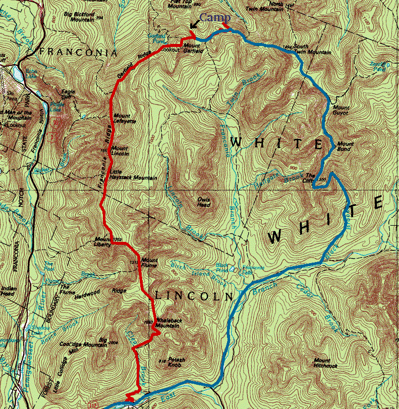
| Winter Pemi Loop |
"This is going to be a big one! Ten to twenty inches tonight, and
continuing into tomorrow". These are not the words you want to hear at 5:30
AM in Plymouth's Dunkin Donuts as you are parting with such gifts of
civilization like a heated room and the number two combo-meal. A Nor'easter
of that magnitude can swiftly erase all the broken trails in the mountains,
and turn an easy hike into a hard one. But what would it change a hard hike
into? We were about to find out!
When you look at the AMC map of the Whites, one obvious loop jumps out at you, perhaps because of the darker green color of the Pemigewasset Wilderness it encircles. Lovingly called "The Pemi Death March" and "The Debilitation Trek" by previous parties, it connects ten 4000 ft. peaks (with optional side-trips to a few more) on the Franconia, Garfield, Twin and Bond ridges along its 32 mile course. In the summer, it has been done as a single-push effort in 16 hours, but winter is a whole different game (to refresh your memory of the 16-hour effort, see Hector's Pemi Trip Report ). We hoped it could be done in two days as we packed a stove, pot, and one freeze-dried dinner each for the planned single bivouac in sleeping bags. Expecting lots of deep powder snow, we also brought along the largest snowshoes we could find, and spent a long evening trying to eliminate all unnecessary gear from our packs.
The packs ended up weighing about 25 pounds as we started into the frigid darkness of the Pemi Wilderness from Lincoln Woods around daybreak. The Osseo trail was in perfect condition, so we soon (read "in 3 hours") stood atop Mount Flume three thousand feet above our car, and enjoyed the familiar view of the Franconia Ridge to the north and the Sandwich Range to the south. But wait a minute, there was no Sandwich Range! Just a dark-gray wall of clouds slowly creeping towards us. The trail was not broken beyond Mount Liberty, but the snow was not deep enough to require snowshoes, so we kept up the pace and tried to outrun the wall. Ahead of us was the Franconia Ridge the key to the whole circuit because of its exposure to the elements. It being January, we had imagined this sharp ridge covered in packed snow, but the mountains presented us with rocks floating in a river of solid ice, only the cairns suggested this was actually the trail. And to the south, there was a dark wall of clouds about to erase Mount Flume from our view. Getting to the top of Mount Lincoln was surprisingly easy despite the ice, but friction was very much lacking as we stumbled down into the col before Lafayette. There, the wall caught up with us and the views disappeared and the wind picked up and we were miserable, walking with a tilt so as not to be blown off the mountain. But the tallest mountain still loomed ahead, so we literally ran up it, envious of the other hikers who were about to head down to Greenleaf hut and their cosy warm cars.
Now, all those hikers thought they had just hiked the Franconia Ridge, but we now know better. The Ridge continues above treeline for a good extra mile as it plunges precipitously towards the much less glamorous Garfield Ridge. We plunged with it, and we were tired, and the ice was slicker, and we were more tired, and then Dave started self-arresting with a hiking pole, and we continued to get more tired, and the trees on Garfield Ridge were still deep below us. At the junction with the Skookumchuck trail, we found a headlamp half encased in clear solid ice; digging it out provided some much-needed rest. The trees grew closer, and suddenly we were among them, up to our waist in pristine snow. Just like last year at this time, the trail was not broken. Sane people do not go to the Garfield Ridge in the winter, and we don't blame them. Garfield "ridge" is actually the Garfield Abyss chock-full of dips, notches, and bumps. We continued our half-controlled free-fall from Lafayette on snowshoes, and life didn't seem too bad. But then came the uphills. And more uphills. And a sudden drop. So even more uphills. And just when we thought we were already climbing Mount Garfield, another drop, this one deeper than the previous ones! Dave started muttering to himself quietly, and I became convinced my altimeter must be broken, but we had to go on.
There were no views waiting at the summit, just the gloom of a raging snowstorm at dusk. Moments later, we stood in front of the Garfield lean-to. The plan had been to camp out in the snow wilderness-style, but the little wooden house looked way too inviting. The powder snowflakes whirled around us, the wind was turning our shells into ice-jackets, and the darkness enveloped us completely. Almost without a discussion, we stepped into the lean-to and made it our home for the night. Fifteen miles and 7000 feet of elevation gain in a little over ten hours had exhausted us so completely, that we bundled up sitting down and restricted motion to lifting of our spoons and pumping up the gas stove to melt enough water for dinner and the next day. And then we slept through the night, our alarm clock, and an early morning visit by a small four-legged animal whose tracks were still visible in the shallow snow on the shelter floor. Eleven hours after turning the stove off, we rose to a foot of powder and wind-driven snow still falling. There were no views that morning, just a faint trail, deep snowdrifts, and more notches. A few hours later, we passed the Galehead hut, and attacked the day's main ascent head on.
The Twinway trail covers the 1100 feet to the summit of South Twin mountain in 0.9 miles, pretty much straight up. Not fun on snowshoes! But after that ordeal, the trail continued much more gently downward towards Mount Guyot, which greeted us with a shower of freezing rain. Welcome to the White Mountains! It is too bad that Guyot doesn't count for "the list" because it is a very pretty rocky outcrop in the sea of boring forest. At this point, only Mount Bond lay between us and the descent to the car. No wonder an intermediate bump convinced us it was "it". The real summit was even nicer, the weather relented a bit and started showing us some of the scenery. Bond is the most remote spot in the Whites, 11 miles from the nearest road. It takes guts to hike towards it all day in a raging Nor'easter, but then again, "guts" rhymes with "nuts". The clock was showing 2 PM, a good time to go down. On the way, we passed over Bondcliff one of the most beautiful summits in the area complete with a classic "hiker on cliff" Kodak situation. We were done mentally, physically, and in terms of ascents, but the car was still ten mind-numbing miles away. Down through small pinetrees laden with fresh snow, down towards more pinetrees laden with fresh snow, down through dark forests towards the Pemi river, down towards the surely broken Wilderness Trail. Wrong! Nobody had made it that far since the storm. So more plodding through deep snow... The last five miles are a blur in our minds. Just a straight tunnel with a white carpet through quiet darkness. But we knew we had succeeded, it was only a matter of time before one reached the suspension bridge at Lincoln Woods, and then the car, the restaurants of Lincoln, the luxuries of civilization.
We made it to the bridge at 7:30 PM, about ten and a half hours after starting in the morning. Not bad for 17 miles of hiking with 2600 feet of elevation gain and a massive elevation loss, most of it through deep powder snow. Would we do it again? Of course not! But if you have an idea for a similar adventure somewhere nearby, let us know!